


The satellite image benchmark archive BigEarthNet, developed by the Remote Sensing Image Analysis (RSIM) and Database Systems and Information Management (DIMA) groups at TU Berlin, has been enriched by Sentinel-1 image patches. This enhances its potential for deep learning with geo data.
The goal of BigEathNet is to create a benchmark archive for earth image patches of Sentinel satellites annotated with land-cover classes. The project receives funding by European Research Council under the ERC Starting Grant BigEarth and by BIFOLD.
The project’s main publication “BigEarthNet: A Large-Scale Benchmark Archive for Remote Sensing Image Understanding“, co-authored by BIFOLD Co-Director Prof. Dr. Volker Markl and Principal Investigator Prof. Dr. Begüm Demir, focused on Sentinel-2 data. In December 2020, the archive has been enriched by matching Sentinel-1 images. The new version contains 590,326 pairs of Sentinel-1 and Sentinel-2 image patches to support research studies on multi-modal/cross-modal image classification, retrieval and search.
By now there are also several tools and datasets related to BigEarthNet developed by external researchers.
THE PAPER:
Authors:
G. Sumbul, M. Charfuelan, B. Demir, V. Markl
Abstract:
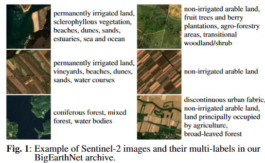
This paper presents the BigEarthNet that is a new large-scale multi-label Sentinel-2 benchmark archive. The BigEarthNet consists of 590,326 Sentinel-2 image patches, each of which is a section of i) 120×120 pixels for 10 m bands; ii) 60×60 pixels for 20 m bands; and iii) 20×20 pixels for 60 m bands. Unlike most of the existing archives, each image patch is annotated by multiple land-cover classes (i.e., multi-labels) that are provided from the CORINE Land Cover database of the year 2018 (CLC 2018). The BigEarth et is significantly larger than the existing archives in remote sensing (RS) and thus is much more convenient to be used as a training source in the context of deep learning. This paper first addresses the limitations of the existing archives and then describes the proper-ties of the BigEarthNet. Experimental results obtained in the framework of RS image scene classification problems show that a shallow Convolutional Neural Network (CNN) architecture trained on the BigEarthNet provides much higher ac-curacy compared to a state-of-the-art CNN model pre-trained on the ImageNet (which is a very popular large-scale bench-mark archive in computer vision). The BigEarthNet opens up promising directions to advance operational RS applications and research in massive Sentinel-2 image archives.
Publication:
G. Sumbul, M. Charfuelan, B. Demir, V. Markl, “BigEarthNet: A Large-Scale Benchmark Archive for Remote Sensing Image Understanding“, IEEE International Geoscience and Remote Sensing Symposium, pp. 5901-5904, Yokohama, Japan, 2019
Authors:
G. Sumbul, M. Charfuelan, B. Demir, V. Markl
Abstract:
This paper presents the BigEarthNet that is a new large-scale multi-label Sentinel-2 benchmark archive. The BigEarthNet consists of 590,326 Sentinel-2 image patches, each of which is a section of i) 120×120 pixels for 10 m bands; ii) 60×60 pixels for 20 m bands; and iii) 20×20 pixels for 60 m bands. Unlike most of the existing archives, each image patch is annotated by multiple land-cover classes (i.e., multi-labels) that are provided from the CORINE Land Cover database of the year 2018 (CLC 2018). The BigEarth et is significantly larger than the existing archives in remote sensing (RS) and thus is much more convenient to be used as a training source in the context of deep learning. This paper first addresses the limitations of the existing archives and then describes the proper-ties of the BigEarthNet. Experimental results obtained in the framework of RS image scene classification problems show that a shallow Convolutional Neural Network (CNN) architecture trained on the BigEarthNet provides much higher ac-curacy compared to a state-of-the-art CNN model pre-trained on the ImageNet (which is a very popular large-scale bench-mark archive in computer vision). The BigEarthNet opens up promising directions to advance operational RS applications and research in massive Sentinel-2 image archives.
Publication:
G. Sumbul, M. Charfuelan, B. Demir, V. Markl, “BigEarthNet: A Large-Scale Benchmark Archive for Remote Sensing Image Understanding“, IEEE International Geoscience and Remote Sensing Symposium, pp. 5901-5904, Yokohama, Japan, 2019